Jackson County becomes transportation hub between East and West
Published on June 24, 2026
Jackson County is celebrating its rich history during its Bicentennial in 2026.
Sitting at the junction of two rivers near the edge of the western frontier, the area that is now Jackson County was destined to become a major transportation hub between the East and West.
The area evolved from a western frontier jumping-off point into a major national transit hub. Its history is driven by westward expansion, the booming railroad area and forward-thinking highway planning that permanently shaped the region’s landscape.
Steamboats transformed Jackson County into the primary jumping-off point for western migration in the 19th century. Paddle-wheelers traveling the Missouri River unloaded thousands of pioneers and massive amounts of freight at river ports at Independence and Westport. The two ports became primary outfitting points where individuals joined wagon trains and prepared for travel on the Santa Fe, Oregon and California Trails.
When the federal government approved the Pacific Railroad Acts promoting construction of a transcontinental railroad, a national boom in railroad lines followed. In 1865 railroad lines finally reached Kansas City, completing an important East – West connection that transformed the region and effectively ended migration on the trails.
The 1869 construction of the Hannibal Bridge over the Missouri River helped to create a crucial rail route to the Northeast. The bridge was the first to cross the river and was a key factor in Kansas City’s development. It enticed a greater number of railroads and businesses to the area which also became a stopping point on the cattle trail.
Hannibal Bridge created a link between Kansas City and Chicago, inspiring the creation of a unified stockyard company in the West Bottoms. In 1870 Philip Armour expanded his meat packing business to Kansas City. The meat packing industry thrived in the city and by 1910, slaughtering and meat packing became the principal industry in the area.
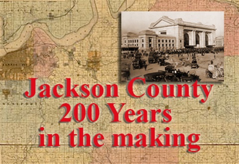
The first train station in Kansas City was built in the West Bottoms in 1864 by the Union Pacific Railroad. After the Hannibal Bridge was built a new station was necessary to accommodate seven new railroads coming into the city. The new Union Depot served as city’s main station until it was replaced in 1914 by Union Station. At its peak during WWII Union Station handled more than 70,000 trains in a single year.
Within the city, Kansas City once boasted one of North America’s largest streetcar systems. Beginning in 1869 with mule-drawn cars, it became a massive cable car network in the 1880s. The system was eventually electrified and slowly replaced by motor buses beginning in the 1920s and phased out by personal vehicles in 1957.
Air travel to Jackson County began in the 1920s. Richards Field was established in 1922 as Kansas City’s first commercial airport located near the border between Kansas City and Raytown. The field was named in honor of John Francisco Richards II, who was shot down during WWI. He was the first Kansas City officer to die while in the Army flying service.
In 1927 Charles Lindbergh visited Kansas City to help dedicate the area’s first municipally owned airfield, Kansas City Municipal Airport. The field was officially opened to airline traffic, with the first terminal building managed by National Air Transport Service.
The airport was built in the Missouri River bottoms next to the rail tracks at the Hannibal Bridge. Transcontinental Air Transport and Western Air Express merged to form TWA in 1931 and selected Kansas City as their global headquarters, becoming the airport’s main tenant. It was named Municipal Airport and later renamed Charles B. Wheeler Downtown Airport in 2002.
Municipal Airport hosted commercial air service to Kansas City until the opening of the Kansas City International Airport in 1972. By then, Municipal Airport was too small to accommodate the larger jet planes that the airlines were using. Today, the Wheeler Downtown Airport continues to serve private air traffic from businesses and individuals while Kansas City International accommodates the larger commercial traffic.
Jackson County’s highway system evolved from the 1820s Santa Fe Trail with major growth under County Judge Harry S. Truman. With Truman’s support voters approved a $6.5 million “Ten-Year Plan” in 1928 to modernize roads and bridges. A visionary highway plan was executed in 1932 resulting in an extensive network of parkways and roads that established the foundation for the county’s transportation infrastructure.
The 1956 Highway Act brought interstates like I-35 and I-70 through the county. This not only created the downtown loop but also cleared historic buildings and altered neighborhoods. The I-435 loop began in 1966 and was completed in 1987, greatly reshaping commuting patterns to the suburbs.
Today, Kansas City contains more than 6,000 lane miles of pavement and Jackson County has more than 425 miles of road in the unincorporated area of the county. A current $350 million project will expand a 25-mile stretch of I-70 to three lanes in both directions. The expansion between Blue Springs to Odessa will make travel along the busiest highway in Missouri safer and less congested.